Sunday, June 26, 2016

Catching up - Skagway, Inside Passage, and on to Tok, Ak.

Apologies for the longer than I prefer blog post....lack of internet and/or connectivity too slow to work is a contributing factor. We have several more photos we'd like to share but that isn't working too good at the moment either. I may update this page with additional photos later if conditions improve.

23 June - Whitehorse to Skagway

     Yay, we can finally say that we made it to Alaska. We departed Whitehorse around 8:00 for the 110 mile drive to Skagway where we stayed at the Garden City RV park. It was a beautiful drive over/through a mountain range with lots of scenic views.

Near the border crossing


     We made a few stops along the way to admire the views and take a few photos. First stop was near a town of Carcross (still in Canada) where we came across what appeared to be a high desert.....lots of sand and sand dunes with the mountain range as a backdrop.....definitely a clash of landscapes but pretty cool to see. They said it is really a dried up lake bed.


Clashing Landscapes


     Next stop was the Caribou Crossing "point of interest" as descried by the milepost. It was an interesting stop as they had a nice wildlife display, a few other animals on display including Alaskan Husky's and some of their pups. In fact when we pulled up, you could hear those dogs howling to get out....sounded cool. They also had a little coffee and do-nut shop that we tried.....took us two donuts each to confirm we liked them :-)

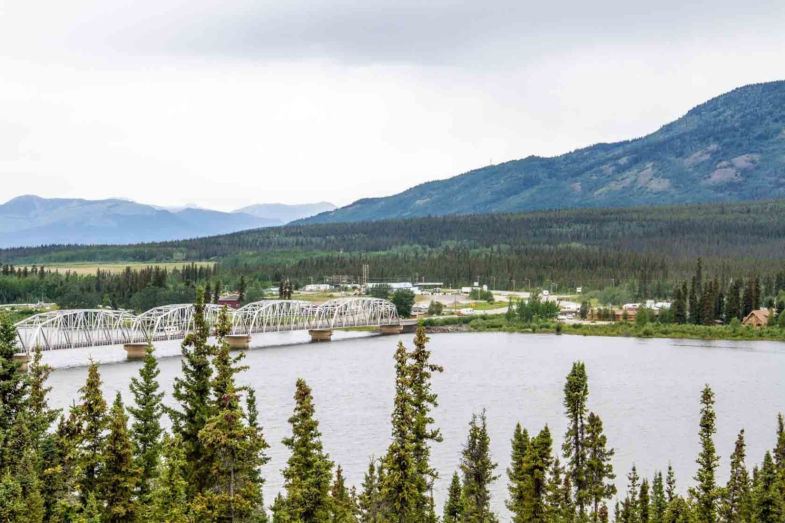
     We crossed the U.S. border, answered a few questions from a stern faced agent and we were on our way. As we got closer to Skagway there were numerous busses leaving town carrying cruise ship passengers out on different excursions. This town (because of the cruise ship population - three ships) was crawling with people.

Rainbow Lake

     After walking through every tee shirt shop in town and identifying where (which pier) our catamaran was leaving from (next day) we headed out to a walking trail and enjoyed a walk around the rim of the bay while Ed and Kay had a little nap. They joined us later in town for a stop into the Red Onion Saloon and Brothel for a drink or two and then dinner at the Skagway Fish House.....everyone but Kay ordered some form of Halibut but it didn't compare to what we had in Whitehorse.
Skagway


24 June - Skagway and Inside Passage

     Fjord Express catamaran was the plan for the day (for Kathy and I) while Ed nursed a cold, that Kay shared with him, they did a little hiking to smugglers cove and rested a bit.

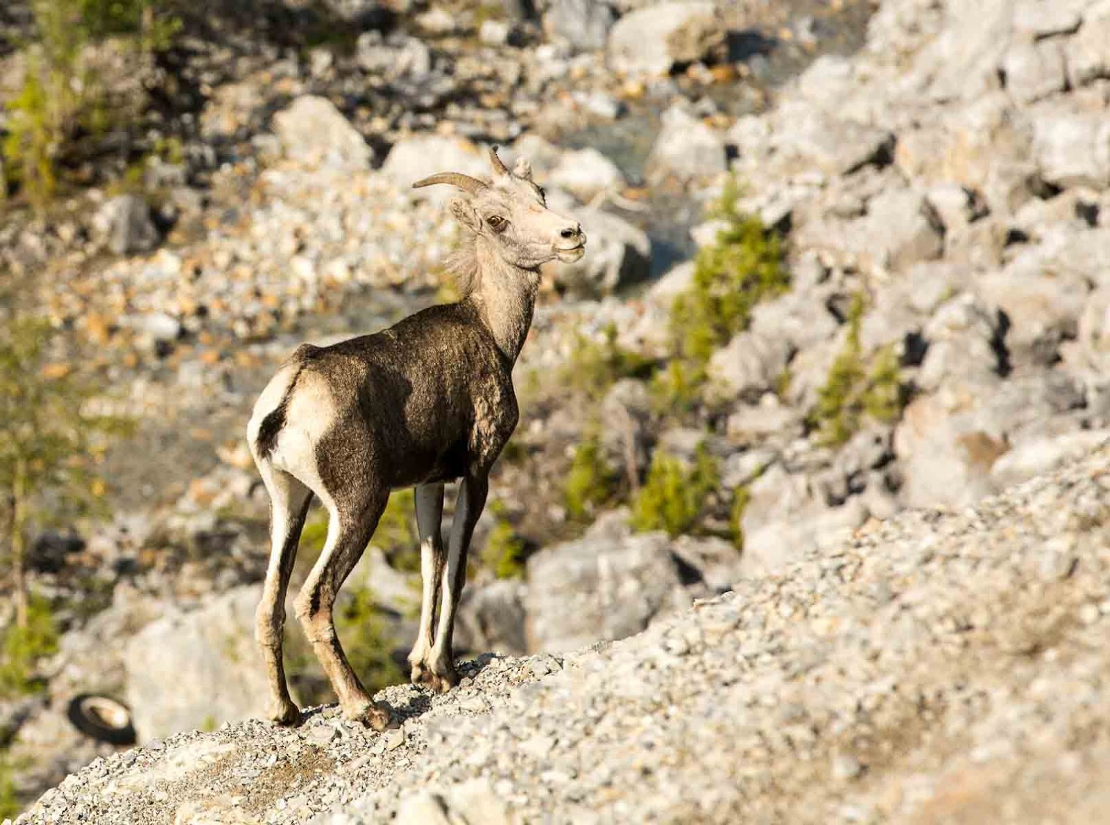
     Our catamaran tour left the dock at 8:00 A.M. and returned at 8:30 P.M. and we were so worn out by the time we returned to camp.....but we had a really nice day despite the weather. We cruised to Juneau but on the way there and back we were looking for (and seeing) lots of wildlife while the guide and first mate taught us much about what we were seeing.

Harbor - Haines, Alaska


     Scenery - although the weather was overcast at first and rained later we saw some spectacular sights. The mountains (Tongus National Forest on one side and Chilkat Mountain range on the other) were only about 4200 feet high but achiviening that from sea level with a straight up climb looked impressive and beautiful. Not sure the photos will do it justice. We were in the Lynn Canal which is 2500 feet deep.

Lighthouse Station - Lynn Canal


     Animals - we saw many eagles, whales, sea lions, otter, and seals. The wildlife was plentiful....just wish the weather would have been more cooperative.

Sea Lion

Humpback Whale


     Once we left the dock we had one stop in Haines to pick up additional passengers and then we were on our way. We pulled into Juneau (well near Juneau where we took a bus) around lunch time with plans to be there until 3:00. We walked every shop in town and I think we doubled our souvenir tee shirt collection. We were going to take the tram up the mountain but it was so foggy that we felt that we would not be able to see much so we skipped it. We did lunch at the Hanger and Bar while we watched the harbor cruise ships and float plane activity.

Whale photobombed the Alaska Ferry Photo


     Our bus driver, Kaitlyn, was very good and funny. She drove us to Mendenhall Glacier where we spent about another hour but it was so nasty weather by then that we viewed it from the visitor's center and watched the movie they had on it. Kaitlyn was good about narrating all we saw on the bus ride. She is originally from Utah and after a couple of years of seasonal work here she has become a full time resident of Juneau. She is single and said the ratio of men to women in Juneau is tilted to more men so she has been told that her "odds are good" to which she replies that the "goods are also odd". Funny girl :-)

     We returned back to camp to learn that Ed had washed his truck and camper and also washed our camper for us....nice surprise because they were getting pretty grubby looking. Since we had driven our truck to the pier I washed it before departing Skagway.

25 June - Skagway to Destruction Bay

Full Moon at Departure
     Time to head out and get back on the Alaska Highway headed for TOK. As we were getting ready to pull out of the campground around 8:30 a camper (Airstream) in the lot caught my eye as Kathy and I had been talking about liking that kind of camper. When I looked over a lady was squatted down peeing just outside the door of the camper in broad daylight.....not sure why because there was likely a bathroom inside and there was definitely a bathroom in the campground a short walk away....we had a good laugh on the way out of that campground. (she didn't notice us laughing or taking a picture)

A little privacy please!


     The ride back over the mountain pass into Skagway that was so beautiful on the way in was shrouded in fog on the way out...visibility was terrible and no photos on the way out of that area....good thing we grabbed a few on the way into town.

International Incident (well almost)
     When we left Skagway and headed back to the Alaska Highway (near Whitehorse) we had to cross the Canadian Border again....Kay was driving their rig at the time and we were following. Ahead of us she handed the agent their passports and he began looking and questioning them as another agent approached our vehicle. They were through ahead of us and pulled over to the side (we thought to wait for us) but Ed was out of the vehicle walking back towards the border guard. Turns out that Kay thought the agent said "have a good day" and she proceeded to pull ahead while Ed was questioning whether he told them to go. When they pulled over and realized that the agent still had their passports it became obvious he had NOT told them to proceed and Ed was walking back to explain what happened and retrieve the passports. By then we were near where the agent that helped them had Ed and asked us if we thought he should let him go or arrest him....we had a good laugh and the agent told Ed that for future reference - the international sign that you are cleared to proceed is "when you get your passports back"! Ed and Kay had a long discussion about the meaning of "Go" versus "Whoa". A good laugh and thankfully a friendly agent!

     A pretty long day of driving and a roadside stop for lunch in the campers and we pulled into a campground called Cottonwood that is about 15 miles south of Destruction Bay in the Yukon and just off the Alaska Highway. As we approached the area we noticed a huge cloud of what appeared to be either smoke or fog over a large lake and entire area....as it turns out (according to the campground lady) the glacier is receding and the river that once fed the lake has dried up and the wind is blowing up silk like particles....really a weird looking environment.

Driving into Lake Kluane


Dust Cloud over lake


     We got settled into a beautiful campsite on the Kluane Lake....largest lake in the Yukon and grilled up some chicken for dinner. Beautiful setting, great meal and great company.
Tomorrow we are on the way to Tok, Alaska

Life is good!

26 June - Destruction Bay to Tok, Alaska

     Departing Destruction Bay and headed to Tok. We almost immediately run into nightmare roads....gravel roads with wash boarding slows our pace to around 10 MPH for many miles. In addition we  came to many construction zones that required us to wait for 15-30 minutes for a pilot vehicle to escort us thru the work zones.....a long day of driving. All of the construction/bad roads were in the Yukon and as soon as we crossed back into Alaska the road conditions improved.

Alaska Highway - under repair


     We pulled over at a roadside stop for lunch that had a beautiful lake and a lot of dragonflies hanging around.

Lunch time company

Lake setting lunch spot

     As we approached the U.S. Customs Kay was driving their rig and she insisted that we stop and let Ed take the wheel.... a little nervous about the border crossings now :-)  I am proud to report that we cleared customs without incident this time and made our way to the Tok RV Village and set up for the evening.

     Moving on to Fairbanks tomorrow.

Wednesday, June 22, 2016

21 & 22 June - Whitehorse, Yukon Territory - Three Nights & Two Days

     A three night (two full days) stop is just what we needed and we couldn't have picked a better place. This town is the capital of the Yukon territory and has a population of 25K people....very small town feel but everything you need in terms of facilities. We are staying at the Caribou RV Park and the owners are an interesting couple...she is from Australia and he is from Sweden (nice folks).

     First full day was a very busy one. We set out for the town to attend an aboriginal festival. We were advised to arrive early and we did....about two hours before it started. So we spent some time walking around the town, a visit to Starbucks (I told you they had all we needed) and a stroll down to tour the Klondike Paddlewheel ship. It was a very interesting exhibit with a movie and free admission. The history of the gold rush days in this area and the hardships they endured is interesting.

S.S.Klondike


     We decided to eat lunch in a popular downtown restaurant called Klondike Rib and Salmon BBQ.....based  on TripAdvisor reviews we all had the fish and chips (Halibut) and it was wonderful. First halibut on the trip and I think it will be difficult to order anything else.

     After lunch we went to the aboriginal festival that was now in full swing. It was a nice "little" small town fair atmosphere with a first nation feel/theme. In one tent they had elders telling stories about hunting experiences, children doing Indian dances, face painting and a jig dancing contest. They did have some food but we already had lunch so we didn't get to try any of the food there.
Youth Dancer at festival


     We managed to squeeze in a quick visit to the Miles Canyon area just before we went out for an evening Vaudeville/Cancan type show. Miles Canyon is a place where the Yukon River is narrowed down to a small canyon and the water is very fast through this area....story goes that many a gold prospectors lost their belongings or even their lives here trying to navigate the swift moving water trying to make their way to Dawson City.

Miles Canyon - Yukon River

Miles Canyon - Suspension Bridge


     The show was called the Frantic Follies and was modeled after the type and style of entertainment that would have been popular during the gold rush days at the turn of the century. Lots of music (ragtime), comedy and dancing. A very nice and fun evening.

     When we came out of the theater at 10:15 it was still day light. The days have been getting progressively longer the farther north we travel...just hadn't commented on it in the blog yet. To give you an idea - the sunrise here tomorrow morning is 4:28 A.M. and the sunset tomorrow evening is 11:37 P.M. and even after the sunset it still is not really dark....just a dusk looking sky. A couple of times on the trip we have awaken to a bright sun coming through the window thinking we'd slept late only to learn it was 5:30 A.M.

      Day two in Whitehorse was a wonderful 70 degrees and sunny and we enjoyed a round of golf at the local course. It was a nine hole course that was in excellent shape....bent grass greens and better fairway grass than I've seen in awhile. The course was pretty short but still par 36....it was a target type course around mountains hills, etc....although the holes were not long, it was not easy to play for the greens off the tee, especially not knowing the course. They also had two cups on each green....one regulation size and one eight inches for beginner players...yes, we played the regulation holes. As we checked in we learned that today was wacky Wednesday...our round included a grilled hamburger (which was great) and chips. A great day it was and good to knock the dust off the clubs.

     Next order of business was to get fueled up for the early morning departure tomorrow, do laundry and buy groceries. While we were busy all day, a nice roast dinner was simmering in the crock pot for us to enjoy this evening.

Moving on to Skagway
      We've made a change in our planned next stop - we were gonna go to Skagway on the way back down (return trip) but we have decided to go tomorrow instead...we are only 110 miles from Skagway now. Kathy and I have booked a cruise tour of the inside passage and Ed and Kay plan to do some hiking as they have cruised the inside passage before.


Sourdough and Sweetdough

Monday, June 20, 2016

Watson Lake to Whitehorse - The Yukon Capital

20 June - Alaska Highway - Day Three

      We woke up in Watson Lake which is famous for the sign post forest. The story goes - back when the Alaska Highway was being built (1942) a homesick soldier stationed here and working on the highway posted a sign saying how far it was to his home in Illinois....it caught on and now it is a tradition for folks traveling thru to post their sign. We didn't come prepared (didn't make a sign before leaving home) but like many others we improvised. I took the Speedway Ford, Griffin Georgia tag off the front of our truck. We cleaned the bugs off it and used a smartie marker to record the distance to our home and our names on it. It was a fun thing to do before hitting the road this morning. There must be thousands of signs there. We sent a text to our friends Jim and Sheila who are a day or two behind and challenged them to find the sign we posted......fat chance :-)


Ready to nail it up!

Sign Post Forest

Pointing to our sign (look up)


      Our plan for the day is to get to Whitehorse, Yukon - the Capital and it is about 275 miles away. Soon after getting on the road we encounter serious/long distance road construction zones. It was heavy gravel roads for estimated 10 (or more)  miles. Being in no hurry we slow to approximately 15-20 miles per hour and begin to wonder if we will make Whitehorse today. Amazingly, several folks come flying around us and I radioed to Dodge-Pepper "they must be the folks that need to hurry so they can get back to work". We continue to move slowly and eventually better roads ahead where we can resume a good traveling speed.

     We pulled into an area called Teslin around noon time and pull over at an overlook of the bridge/lake and prepare some lunch in the RVs. We also went to a roadside store/gas station there for fuel. Diesel fuel there (remote area) was around $3.15 per gallon (converted liters and Canadian Dollars)....not bad for the remote area. Gas has been slightly higher than diesel at all stations so far. There was also a group of bikers there that were doing the Alaska highway....many Harleys and some other bikes that were loaded like mules. As we left the temp dropped a bit and it was raining lightly - glad we were in a truck/RV.

Think this guy was loaded down?
Not a Harley but there were many out there!


Teslin Overlook


     The road between Watson Lake and Whitehorse offered nice views of mountains, valleys, rivers, forests, and wildflowers. No wildlife at all this day though. We have laughed several times....a lot of Caribou signs but not many signs of Caribou. Kathy and I have still not seen a Moose or Caribou.
We pulled into Whitehorse around 5:00 and were glad to be here.....tired and hungry. Kathy and I were cooking tonight and after a run to town for some needed supplies we enjoyed a nice spaghetti dinner with Ed and Kay before calling it a night. We plan to spend three nights here...some sights to see, maybe some golf (hopefully), rest and replenishing some supplies before moving on.

Alaska Highway Scenery

Alaska Highway Scenery

Sunday, June 19, 2016

Jasper to Dawson Creek, B.C., (30 day check up) & 600 miles of Alaska Highway

Thirty Day Checkup
  • Actually five days ago marked the 30 day point for Kathy and I.....Ed and Kay are a couple weeks (and a few more scars) behind us. They are not many miles behind us but they changed horses ;-)
  • We have traveled 6,335 miles to this point since leaving home
  • We have seen 7 states and 3 Canadian provinces so far
  • We are currently 3,356 miles from home
  • And we are still 657  miles from Alaska (Tok, Ak - our first planned point of entry)
  • But we are doing well and having the time of our lives
16 June - Drive from Alberta to Dawson Creek

     We departed the Whistler's Campground in Jasper National Park around 8:00 headed for about a 320 mile run up to Dawson Creek in British Columbia which is where the Alaska Highway starts at mile marker "0". This leg was on a two lane secondary road called the Big Horn Highway.

     We had views of mountains for much of the drive but eventually got into some pretty remote heavy forest areas. The logging industry was very big in that part of Alberta and heavy trucks have taken a toll on the roads....not terrible but heavily worn in spots and a lot of road work. Also along this stretch the towns were  few and far between....gas stations too - I remember seeing signs saying the next gas station is 184 Kilometers (about 115 miles) so you need to plan carefully. Glad I installed an auxiliary fuel tank.

     We stopped in one of the small towns called Grand Cache and refueled and found a diner called the Big Horn Restaurant and Pub where we had lunch. "Would you like gravy on your fries" the waitress asked all four of us.....I was the only taker - when in Rome, right? It was not bad but not sure I'd do it again.

     My weather lady and co-pilot had been keeping an eye on the Dawson Creek weather in anticipation of our arrival because we hoped to spend a couple days here shopping for supplies, doing laundry, and weather permitting, playing some golf. She kept seeing rain advisories for the couple of days prior and it did rain a little the day of our arrival but the following days were to be in the 70's and sunny (sign me up for some of that). As we got closer to Dawson Creek on the drive in, there were a couple places where flood water was crossing the road and we could see farms and homes with a lot of rising water. Turns out the town is flooding pretty bad.

Highway 43 headed to Dawson Creek


     As we follow the GPS to our campground we approach a bridge that appears to be washing out so we are detoured to another bridge that was closed by the time we got there. Like good campers do, we headed for the Walmart parking lot to regroup and come up with a plan. We learned from our friends Jim and Sheila (who were ahead of us a bit) that there was an alternative way and they told us how to get there. Ironically, the alternative way took us right by the Dawson Creek County Club and Golf Course which, you guessed it, was mostly under water. Won't be playing golf in Dawson Creek and we immediately turned our planned three night stop into two and began wondering if there would be other issues up thee Alaska Highway.

Hole #3 at Dawson Creek Country Club
(cancel our tee time please!)


     We finally get settled into camp about 6:00 P.M. local time.....we gained another hour on this leg.....now three hours behind the east coast. After setting up we were really glad that I had grilled a pork tenderloin the night before (while Ed grilled the chicken) so dinner tonight was pretty easy to prepare. Four tired pups went to bed soon after dinner.

17 June - Dawson Creek down day

     The weather is perfect for golf if the ground was not so saturated and the course flooded. We are still taking full advantage of our stop to rest, catch up on chores/maintenance, etc.... This is the first day in awhile that I would consider wearing shorts, I'm not but did consider it. It is a very nice 63 degrees and sunny with little wind. Feels great!

     Grocery shopping and laundry were high on the list for us and the Culpeppers and I needed to try  catching up on the blog while I had service and electricity. It was a pretty productive day and we managed to get some much needed rest also.

     We went to the mile marker "0" for a photo session this afternoon and after that we decided to run north on the Alaska Highway for 20 minutes or so without the trailers to see an old wooden bridge called the Kiskatinaw Bridge. It was part of the original highway and is an amazing piece of work....a wooden bridge that is curved and still in use today...we just didn't think driving our RVs across it was a good idea. This part of the Alaska Highway has been rerouted.

     Heading north to Fort Nelson tomorrow.

Mile Marker "0" Photo

Kiskatinaw Bridge - built 1942


Ed & Kay


18 June - Alaska Highway - Dawson Creek to Summit Lake

     As we left the campground in Dawson Creek both Kathy and I commented on how warm it was and we wished we'd put on shorts....really felt hot to us. We looked at the thermometer on the truck and it was 59 degrees....you know you've had some cool weather when you complain about the heat at 59 :-)

     We said good bye to Jim and Sheila as we left the Mile "0" campground headed up the Alaska Highway. They had met many of the folks that were gathering there for their caravan. We promised to meet for lunch some time in Atlanta or Chattanooga to compare notes of our Alaska trips. Our travel plans for this day were to make it to Fort Nelson and spend the night but we had such a good travel day that it was just 3:00 or so when we arrived there and we decided to press on a bit farther.

My first impressions based on the first 350 miles of the Alaska highway were:
  • The road is better than expected (I'd heard some horror stories)
  • Not much wildlife for the longest stretch but just before Fort Nelson we started seeing bears
  • Not many people or homes anywhere
  • A lot of natural gas industry and several work camp type lodging facilities
  • Lots of wilderness and not much traffic
  • It could get lonely out here - glad Ed and Kay are with us
Alaska Highway (from first 350 Miles)

Alaska Highway (from first 350 Miles)

Alaska Highway Construction Zone (from first 350 Miles)


     Just prior to arriving at Fort Nelson (within the last 30 miles) we began seeing some black bears in the area just off the highway and we naturally had to try photographing them. We ended up seeing 7 or 8 of them and after the first several we just rode by and admired them. (No more photos). Kathy did manage to get a good/different looking black bear photo that we were quite entertained by. As she shot the picture she said she thought the bear was peeing....liquid flying as he reared back. On the back of the camera we got tickled trying to figure out if that is what it was and identify the body parts we were seeing. After getting it on the computer we realized that the Bear was in or near some water (creek or ditch that we couldn't see) and when we raised his paw to scratch the wet paw slung water everywhere.....a unique photo none the less.

Kathy's Wet Bear

Look at those teeth

  
      When we rolled into Fort Nelson we had a team meeting to discuss how much farther to go and when to stop. In our trusty Milepost (Alcan Travel Guide) Kathy had read me an article about a campground on the Tetsa River where they also had a bakery and brag about the cinnamon rolls fresh baked.....that sounded like a good target to me so we headed there. Upon arrival, the smell of cinnamon buns was nice but they had none left and wouldn't have anymore 'til morning. Although we were temped to stay, they only had 15 amp service and we decided to push on a bit farther.

     Another 20-30 miles we came upon a Provincial Park (much like our state parks) that was called Summit/Stone Mountain Park....turns out it is the highest location on the Alaska Highway at 4200 feet and the campground was in between some mountain peaks and right on a lake and stream.....no hook ups - no phone, no internet, no problem ;-) but a nice setting and the price was right. We set up camp, grilled some pork chops and were able to sit outside (72 degrees today) and enjoy the weather.

     This area is known for Stone Sheep and a park employee told us they were out a couple miles down the road while we were cooking. After dinner we rode down to see if we could find them but no luck.

Summit Lake Campsite

Lake Summit Wild Flower


19 June - Summit Lake to Watson Lake

     We all agreed that Summit Lake was a great stop....most of us slept well (not Ed) and it was just a beautiful setting. Before we got on the road to our next scheduled stop (Watson Lake) we took another ride (without campers) to look for the stone sheep and sure enough, eagle eye Ed spotted a group of them and we enjoyed watching and  photographing them before returning to hook up the campers.

Young Stone Sheep


     We had travel plans to make it to Watson Lake, only about 240 miles away but a couple scheduled stops on the way.....not counting the unscheduled animal stops.....there were many. Ed and Kay had the lead and not long on the road they spotted a female moose (first one on this trip) but by the time Kathy and I got there she was heading into the woods so no photos. They ended up seeing another moose later in the day, again when they were well ahead of us and we missed that one as well.

Alaska Highway Construction zone

Alaska Highway


     First stop was Muncho Lake - a really large and pretty mountain lake. Ed and Kay camped here on their trip ten years ago. It was a good break from the drive to get out and walk around a bit. And as we were leaving that area we saw some more stone sheep really close to the highway and they did not seem as skittish as the ones at Summit Lake in the morning.
Baby Stone Sheep

Muncho Lake

     By the end of the day we had also seen several more bears  including a cinnamon brown black bear....I think that is right but honestly they are all grizzlies to me. We did manage a few good photos....can't stop photographing the bears.

Cinnamon black Bear (I think)


     We pulled into a Provincial Park called Liard Hot Springs as lunch time approached. This too was a scheduled stop as we wanted to experience the springs. After fixing some lunch in the campers and changing over to our bathing suits we headed down the boardwalk for the springs. They are a natural spring that maintains between 107 and 127 degrees. It felt great and was very warm. Only mishap there was Ed jumping in without first taking his hearing aide out....not sure yet if it will live.

Liard Hot Springs


     Leaving Liard Hot Springs with the water truck leading....oh yes, we have walkie talkies and my handle is "Water Truck" and Ed is "Dodge-Pepper." I tried to give him a handle with diesel in it....Diesel Dan, etc... but he was sick of diesels at this point and wouldn't have it.

     As we rolled on across the Yukon border just prior to getting into Watson lake we stopped at a place fuel stop/store that Paul and Eugenia (people we met in Columbia Falls from Mitchell County) recommended called Contact Creek....said the couple running it were originally from Florida and had moved here in 1979. I asked the guy about the winters and he said he nearly froze to death the first winter it got to -70 degrees but he is used to it now.

     We pulled into Watson Lake and are at a full service campground  but the power has gone out at least four or five times already. Someone said this town produces all power via generators and the heat (83 degrees today) has put an overload on them. We walked across the street to a local diner to eat and then went to a Northern Lights Planetarium show. Ed made up for the sleep he lost last night in that show.

     Heading out for Whitehorse, Yukon Territory tomorrow.